


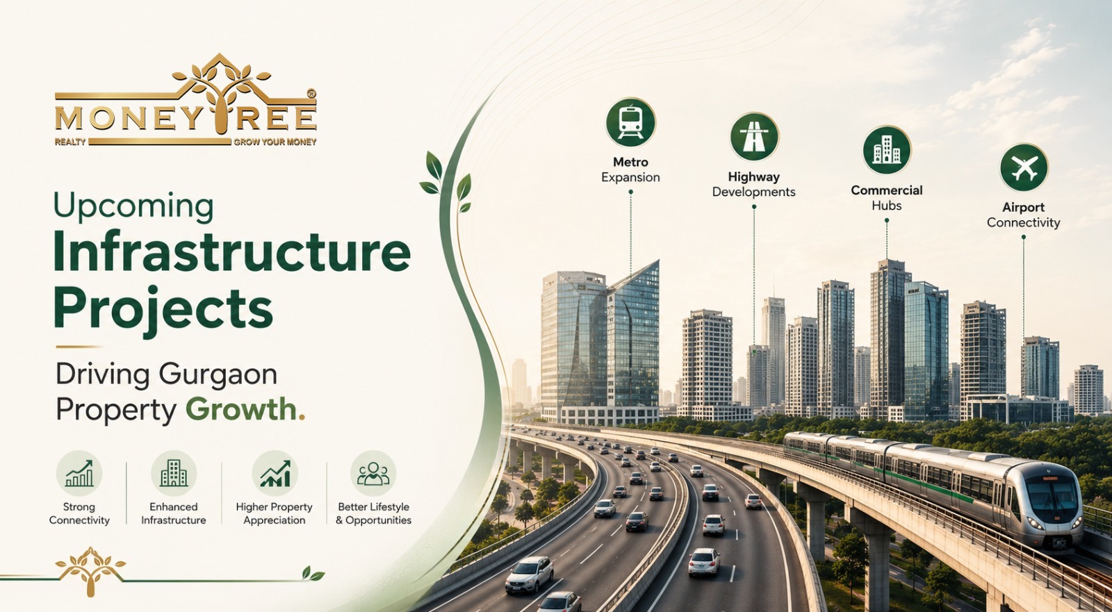


Table of Contents
The Atal Bihari Vajpayee Sewri–Nhava Sheva Atal Setu, better known as the Mumbai Trans Harbour Link (MTHL), is India's longest sea bridge with 21.8 km length, a 6 lane lane elevated highway which connects Sewri in Mumbai to Chirle in Navi Mumbai. This engineering marvel reduces the commute between Mumbai and Navi Mumbai from 2 hours to 20- 30 minutes significantly improving the physical, economical, social and commercial connectivity and bettering the life of Mumbaikars.
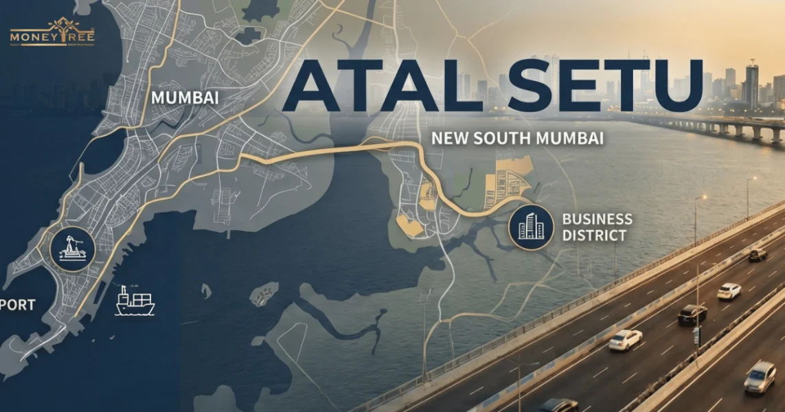
How MTHL (Atal Setu) Expansion Is Creating a “New South Mumbai” in Navi Mumbai?
In 2026, the “New South Mumbai” is no longer a marketing hype, it is a reality presented before the entire Mumbai to see and experience. With the construction of Mumbai Trans Harbour Link , Mumbai will be able to soar both its northern and southern wings and not keep the development of the northern Mumbai flapped shut.
Within history, the southern islands of South Mumbai separated by the waterbody Thane Creek has always gained the attention of the government as well as developers thus attracting major commercial and prestigious legacy marginalising the mainlands of Mumbai.
One of the major reasons for this marginalization has been the physical distance between Navi Mumbai and South Mumbai which posed the problem for the government about its structural redevelopment. Even after many redevelopments programs and schemes in Navi Mumbai, it failed to gain the attention of locals as well as businesses with South Mumbai still dominating the Mumbai hub. The government solved this discourse by the Atal Bihari Vajpayee Sewri–Nhava Sheva Atal Setu project.
This 6 lane elevated highway has resolved the issue by providing connectivity between both the important locations of Mumbai thus redistributing the development goals for overall Mumbai city and instigating vision for a holistically developed Mumbai. This project is expected to reduce the widening gap between elite and underdeveloped parts of Mumbai.
Built six decades after its proposal, the Mumbai trans harbour link is also an engineering fascination with the amount of steel used in it that can construct seven Eiffel towers and lightening systems that do not disturb the aquarius life.
The Death Of Distance
By 2026, the phrase "Death of Distance" describes how much Mumbai’s urban geography has changed. For many years, South Mumbai was an exclusive area, not because of laws, but because a 2.5-hour commute kept it separate from the rest of the city. This long separation shaped Mumbai’s social and economic life. Before 2024, the cost of living on the mainland, like in Navi Mumbai, was measured in time.
Getting to important financial districts such as the Stock Exchange or Nariman Point meant dealing with heavy traffic on the Vashi Bridge and through Sion. When the 21.8 km Atal Setu opened, everything changed.
The Sewri-Nhava Sheva corridor now gives India’s fastest high-speed transit, cutting commute times to just 20-25 minutes. As a result, companies in South Mumbai are hiring more people from the mainland, since long commutes are no longer a problem.
Sewri- Nhava: The New Gateway
Historically, a quiet industrial neighborhood known for its oil boundaries, coal bunkers, oil tanks, warehouses. and flamingo mudflats, Sewri has become the "Zero Point" for Mumbai’s new geography.
It has become the central nexus where all of the city's major high-speed roadways intersect.This allows a traveler to move from the West Coast (Worli) to the East Coast (Sewri) and then to the Mainland (Navi Mumbai) without hitting a single traffic light.Sewri is the only place in the Mumbai Metropolitan Region where three massive infrastructure projects meet, allowing you to bypass the city's internal traffic entirely: the east-west corridor, the mainland-island corridor and the southern-northern corridor.It is now the "front door" for anyone entering Mumbai from the new Airport or the Pune Expressway.
Despite the high-speed transit, the Sewri end features a 2 km "Silent Zone" with vision and noise barriers to protect the migratory flamingo population that inhabits the mudflats below the bridge. The bridge terminates at Chirle in the Uran taluka, fundamentally changing the economy of the Raigad district.
Jawaharlal Lal Nehru Port(JNPA)
In 2026, the synergy between the Jawaharlal Nehru Port Authority (JNPA) and the Atal Setu (MTHL) transformed the port from an isolated industrial giant into a hyper-connected global hub.
The link between the Jawaharlal Nehru Port Authority (JNPA) and the Atal Setu has greatly improved how cargo moves into Mumbai. Earlier, goods took nearly three hours to reach the city because most trucks had to pass through the crowded Vashi route and travel a long 140-km loop toward Bhiwandi. Now, the Mumbai Trans Harbour Link allows cargo to reach Mumbai in about 20 minutes.
This has reduced travel time, lowered transport costs, and cut down fuel use and carbon emissions Furthermore, the bridge has bridged the professional divide, allowing senior port management and specialized "white-collar" engineers to reside in South Mumbai while maintaining a short, signal-free commute to the port’s high-tech operations centers on the mainland.
Navi Mumbai International Airport
With the recent commencement of Navi Mumbai International port on 25th December 2025, the burden on the world’s busiest single runway airport , Chhatrapati Shivaji Maharaj International Airport will be lifted, providing the vision for redistribution of development in New Mumbai, an edge.
The Atal Setu has turned the Navi Mumbai Airport from a "satellite airport" into the primary international hub for the southern half of the Mumbai Metropolitan Region.Without this bridge, the new airport would have been geographically isolated from the city's financial heart; with it, the airport is now functionally "closer" to South Mumbai than the old Sahar airport.
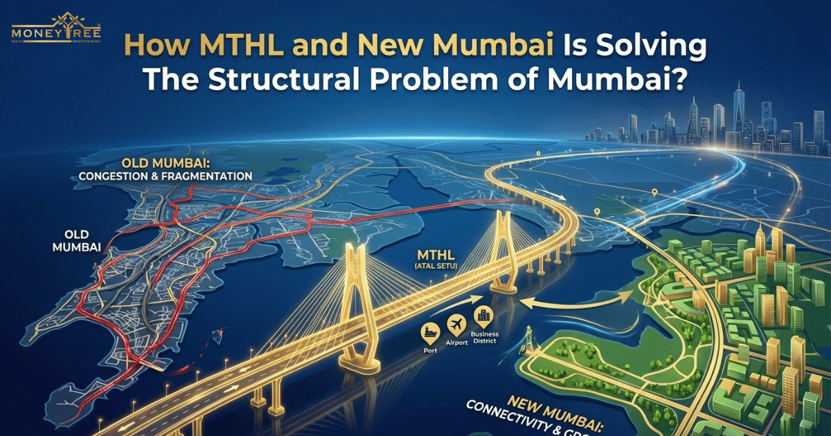
How MTHL and New Mumbai Is Solving The Structural Problem of Mumbai?
In 2026, the Atal Setu (MTHL) serves as the critical "trillion-dollar spine" of the Mumbai Metropolitan Region, transforming the city from a linear, congested island into a circular, hyper-connected mega-metropolis.
The Peninsular Problem
Mumbai 3.0 (Third Mumbai) is not meant to compete with South Mumbai’s heritage but to solve problems that the old city’s geography can no longer handle. Built on a narrow strip of land, Mumbai was forced to grow only northward, creating severe congestion and one-way commuting patterns.
The Mumbai Trans Harbour Link (Atal Setu) is transforming this linear city into a more circular one by opening up 324 sq. km of land in the east, easing overcrowding and allowing more balanced urban growth.This allows the city to breathe, redistributing the population rather than stacking people on top of each other.This is very crucial for Mumbai’s overflowing population and crowded slums as labourers and workers keep migrating to the city of dreams.
The Great Mumbai Traffic
By 2026, the Atal Setu will have made travel in Mumbai much faster by cutting a two-hour trip down to about 20 minutes. It diverts around 23,000 vehicles each day from the crowded Vashi Bridge and Sion–Panvel Highway, easing traffic at the city’s eastern entry point.
The bridge uses Open Road Tolling, so vehicles do not have to stop at toll booths and can keep moving at high speed. This direct route between South Mumbai and the mainland saves fuel, keeps heavy trucks out of city roads, and offers a signal-free drive to the new Navi Mumbai Airport.
The Economic Bridge
The Mumbai Trans Harbour link is doing what the Brooklyn bridge had done to New York, bridging the economic and development gaps. The Atal Setu and Mumbai 3.0 effectively "collapse" the economic distance between the island city and the mainland. By slashing travel time to 20 minutes, the bridge turns the mainland into a functional extension of South Mumbai, allowing professionals to access high-paying jobs while living in affordable, high-growth nodes like Ulwe.
This shift equalizes real estate values, as mainland prices catch up to traditional hubs. Meanwhile, Mumbai 3.0 introduces a white-collar economy to the Raigad district through new "Innovation Zones" and global business districts, ensuring that the prosperity once trapped in South Mumbai now flows across a unified, circular mega-metropolis.
What’s New in Mumbai 3.0?
In late 2024 and 2025, the Maharashtra government officially designated the region around the MTHL’s landing point as Karnala-Sai-Chirner (KSC) New Town, popularly known as Third Mumbai. A 2BHK in a decent South Mumbai building can cost ₹8-12 Crores. This has pushed the "middle class",the doctors, engineers, and teachers who run the city, to live 2 hours away in the suburbs.Mumbai 3.0 offers "New South Mumbai" lifestyle amenities at 25% of the cost.
The Atal Setu and Mumbai 3.0 are giving Mumbaikars the access to their time back. No one is going to waste their precious 2 hours in the insane Mumbai traffic.Now, that 20-minute drive across the sea turns a stressful journey into a sunset cruise, making the mainland its front row neighborhood. It allows young families to stop compromising because you can work in a SoBo high-rise but come home to a spacious, green 3-BHK in Ulwe.
By merging both shores, the project has erased the social divide, creating one unified, high-speed heartbeat for all Mumbaikars giving them both facilities and peace of mind. Mumbai, the city which never sleeps, may now get a good night's sleep.
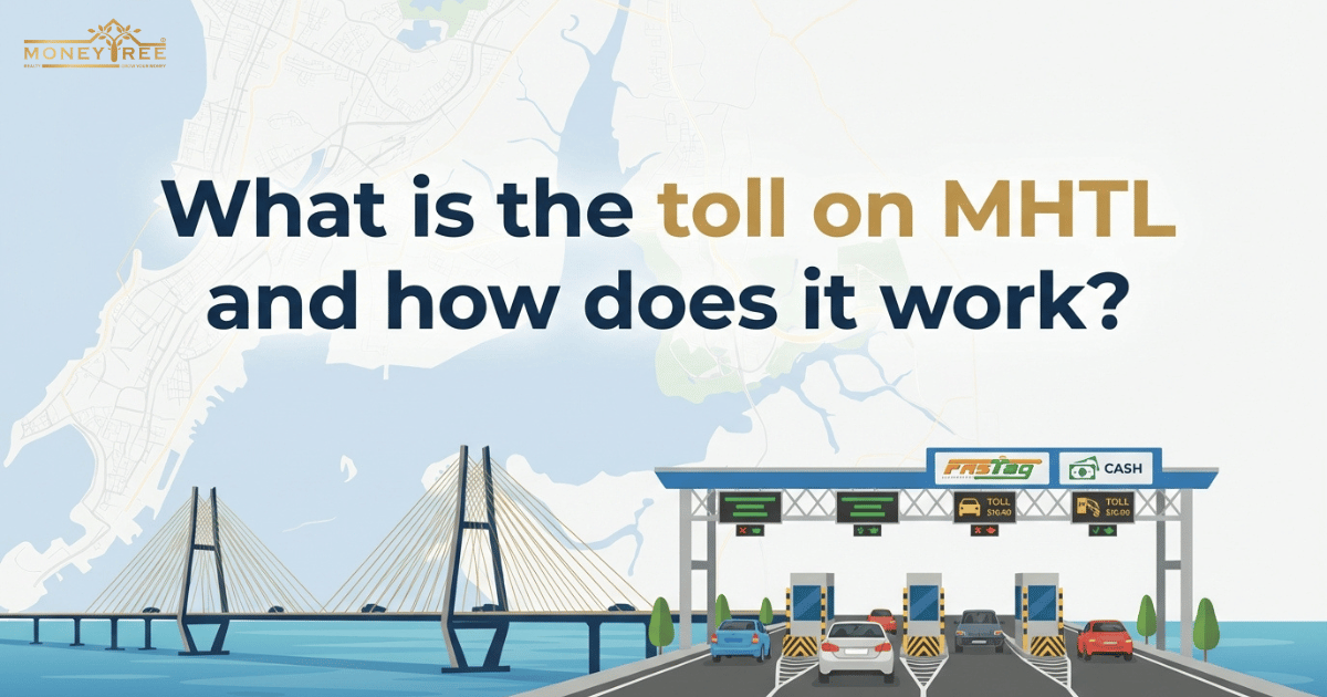
What is the toll on MHTL and how does it work?
ans-As of January 2026, the Maharashtra Cabinet has officially extended the 50% concessional toll rates for the Atal Setu (MTHL) through December 31, 2026.
| Vehicle Type | Single Trip | Return Journey | Daily Pass | Monthly Pass |
|---|---|---|---|---|
| Cars / SUVs / LMVs | ₹250 | ₹375 | ₹625 | ₹12,500 |
| Electric Vehicles (EVs) | FREE | FREE | FREE | FREE |
| LCVs / Minibuses | ₹400 | ₹600 | ₹1,000 | ₹20,000 |
| Buses / 2-Axle Trucks | ₹830 | ₹1,245 | ₹2,075 | ₹41,500 |
| 3-Axle Trucks | ₹905 | ₹1,360 | ₹2,265 | ₹45,250 |
| 4–6 Axle Vehicles | ₹1,300 | ₹1,950 | ₹3,250 | ₹65,000 |
Final Note
The Atal Setu and Mumbai 3.0 have fundamentally redefined the city, turning a grueling two-hour commute into a 20-minute coastal breeze. This infrastructure marvel has merged South Mumbai’s prestige with the mainland’s vast potential, making the new airport and JNP Port globally competitive hubs. Navigating this high-growth landscape requires the expertise of MoneyTree Realty.
As a premier real estate advisory, MoneyTree Realty specializes in identifying high-yield opportunities in Sewri and the "Third Mumbai" corridor. They bridge the gap for investors, turning these massive infrastructure shifts into profitable assets. With MoneyTree Realty, you don't just watch Mumbai transform, you lead the way.
Frequently Asked Questions